During the past week, we were encouraged by the first real snowfall in the Cascades this fall, with some locations getting 20-30 inches. Steven Pass, hit by some convergence zone precipitation, has 24 inches and is just short of opening. But like a snow mirage, the Cascade snowpack is about to disappear as warm temperatures and heavy rain hits the mountain barrier.

The current NOAA snow analysis shows 5-30 inches in the Cascades
Some mountain locations will get 5-10 inches of RAIN before the next few days are up and several rivers draining into Puget Sound will hit flood stage. Winds get blustery over Northwest Washington and downright windy along the coast. Normal weather that will make for a cozy Thanksgiving dinner or some personal time with a book or tablet.
Today (Monday) was a day of profound rainshadowing with westerly flow approaching our region, with the precipitation associated with a warm front.


But all hell is about to break loose, precipitation-wise, and because of the warmth, temperature-wise. Skiers in particular will curse the approach of the evil one.
Stage 1 has already begun. Warm, moist air immediately behind the warm front is flooding in aloft, but the flow will remain westerly. Over the next 24-h, heavy precipitation will hit Washington, with as much as 2-7 inches in the central and southern Cascades. Puget Sound will be substantially rain-shadowed by the Olympics.
.gif)

And the moisture field over the eastern Pacific shows a modest atmospheric river...a narrow plume of high water vapor content headed right for us, after starting near Hawaii.


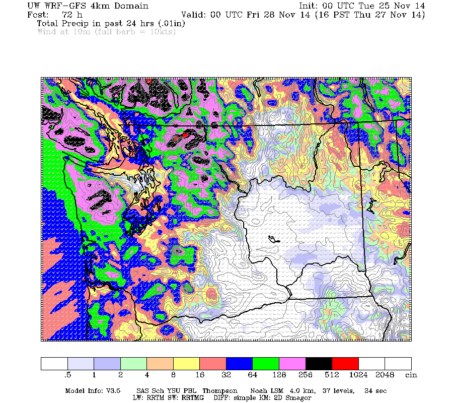
Add the entire 72h together over the region and here is what you get: 5-10 inches over the north Cascades, Vancouver Island, and the extension of the Cascades into BC. Less over the Puget Sound lowlands and practically nothing from Yakima southward on the eastern slopes.

With lots of rain and snow melt, the National Weather Service has a flood watch now:
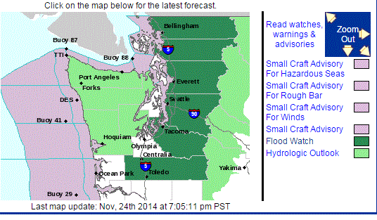
And the National Weather Service River Forecast Center is predicting flooding on several major rivers draining into Puget Sound, like Snoqualmie, Snohomish, Stillaguamish, Nooksack, and Cowlitz.

The snowpack is going to be radically reduced.
But there is so much more. The atmospheric river will then head south to California, where they will get a major precipitation event--which is sorely needed.
And cold air may come back this weekend, with the possibility of lowland snow west of the Cascade crest!
As they say, when it rains, it pours....
Ask a question to be answered on-air on KPLU
Would you like to ask a question that I could answer during my radio show on Fridays at 9 AM? You can submit it on this website. The segment is repeated later during that day as well. KPLU is 88.5 Mhz for most of you and you can also listen online.
.gif)


Cliff,
ReplyDeleteDo you ever use the CoCoRaHS data? With storm events such as we are having now, I find it interesting how rainfall is distributed across the region.
http://www.cocorahs.org
Steve
Sorry to interrupt for an OT, but the Amazon Fire Phone has a barometer, and is now unlocked for $199. I know you were asking for Google to crowdsource, but Amazon is headquartered locally.
ReplyDelete