Arctic air east of the Rockies. Below freezing air in eastern Washington. And colder than normal temperatures with nighttime freezing temperatures in western Washington.
Over much of the region there will be lots of sunshine...a gift for mid-November. But we will pay for it with gale-force winds in topographically favored locations. And as a special bonus, some of the lowlands near Portland and in the Gorge may get a dusting of snow later in the week.
My kind of weather.
Lets start with the lower-atmosphere temperature (about 3000 ft above sea level, color shades, blue and purple are cold), sea level pressure (solid lines), and winds at 4 PM Monday. High pressure and cold air east of the Rockies.

.gif)
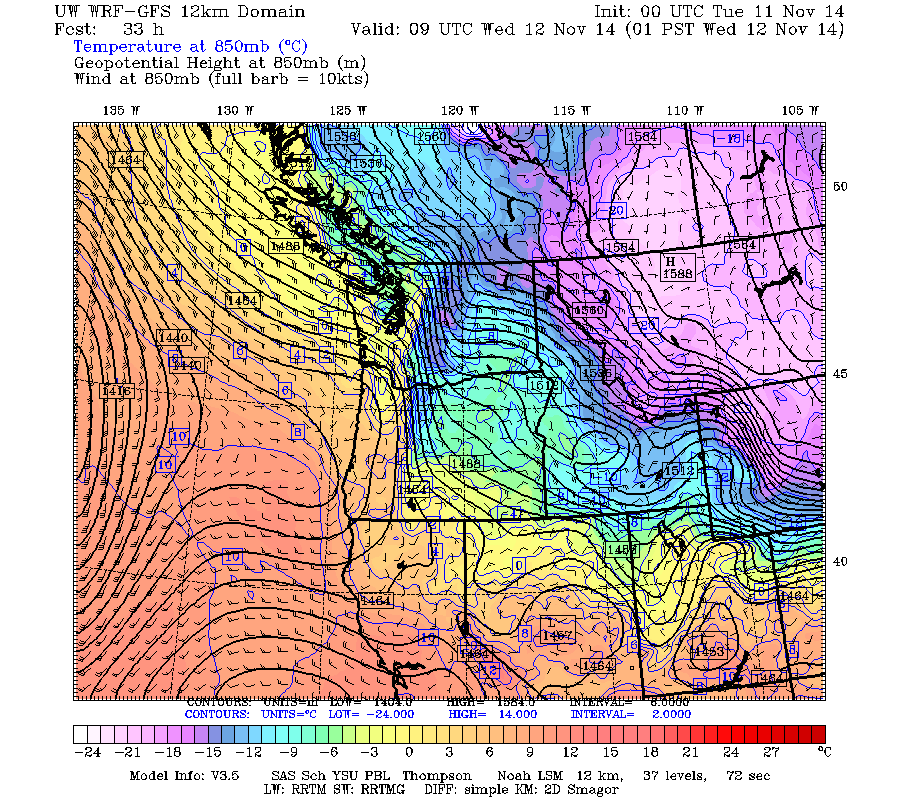
Go to a higher level (around 5000 ft...850 hPa) on Wed. morning around 1 AM you can see the coldest air in Montana (light purple) and a big change in temperature and pressure across the Cascades. Really nice example of how our mountain barriers reduce the westward push of cold air from the interior of the continent. The flow aloft is generally southeasterly and fairly strong....very different from our normal westerly flow.
The surface wind pattern predicted for the same time in fascinating (see below). With easterly winds aloft and much higher pressure east of the mountains, air is pushing through the gaps in the Cascades. Some northeasterly flow pushes through the Fraser River valley and across Blaine and the northern San Juans. Some air accelerates eastward (sustained 35 knots) in the Strait of Juan de Fuca. Strong winds (sustained 35 kts with stronger gusts) descend the western slopes of the Cascades with particularly strong flow around Enumclaw and Black Diamond and pushing across south Seattle.
Easterly flow is split by the Olympics and converges again over the Pacific.

Temperatures will drop below freezing on many locations in western Washington on Wednesday morning. To illustrate here is the graphical temperature forecast by the National Weather Service.

On Thursday, with cool air in place and even cooler air coming through the Columbia Gorge, a moist weather system will approach from the southwest. The models are producing very light snow near Portland and over the Gorge starting that morning (see below). It won't reach Seattle (so Mayor Murray will be able to sleep soundly that night).


Welcome to winter.
ReplyDeleteI find it interesting that the NWS stubbornly has not issued a wind advisory for the Puget Sound Lowlands even though wind speeds have been solidly up to advisory criteria all morning.
ReplyDeleteThis may be your kind of weather, Cliff, but this particular kind of high pressure is one of my migraine triggers.
ReplyDeleteTell me it'll be over soon, please?