The Cascade Mountain snowpack right now is sparse, far worse than last year. Yes, Thanksgiving downhill skiing is always iffy in our region, but usually there is enough for some cross country fun. But this year is questionable. Only places that can make snow (like Whistler) have a decent chance of opening soon. But there is a glimmer of hope...

Not much snow at the top of Crystal Mountain
.
Paradise Visitor Center on Mt. Rainier. One of the snowiest places on the planet. Usually.
In October we had lots of precipitation, but we were also very warm, so that even higher elevations had rain.
Then during the past week we have been very cold, but also very dry except for a band of light snow in northern Oregon a few days ago.
Let's look at the latest snow depth analysis from NOAA. Here is the snow depth analysis for today (Nov. 16th). Very little in the Washington Cascades, but some light snow over the northern Oregon Cascades and northeastern Oregon. Timberline Lodge at Mount Hood, which got a piece of this, only has 9 inches on the ground. But there is one place that did well during this event: Mt. Batchelor, with roughly 2 feet.

To give you some perspective on the current situation, here are the snow depth analysis for exactly the same date in 2013, 2012, and 2011. A LOT MORE in the Washington Cascades.


We are now close enough to Thanksgiving for our models to have some skill. But first lets look at the Climate Prediction Center forecasts for the 6-10 day outlook. Oh, oh...warmer than normal.


Let's take a look at some of the latest model runs.
Here is the upper level map (500 hPa) for today. Big ridge over the West Coast. Dry.


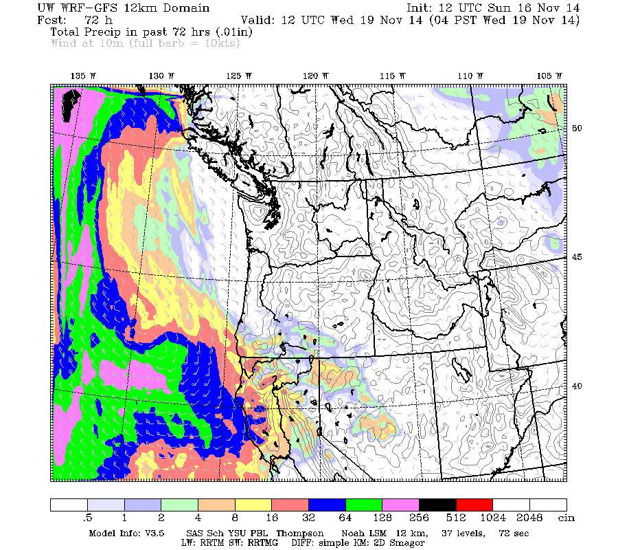
The precipitation over the next 72h reflects this. Those poor devils in California need all the precipitation they can get.
Then a series of weak weather disturbances break through later in the week...we get wet, but will be warm. Not good for snow at ski areas or the passes.

The only hope is that some of the models are suggesting a major shift late next week, with the jet stream barreling in on us. Here is the 500 hPa upper level forecast (solid lines are heights) for Saturday AM from the U.S. GFS model

and the European Model at 4 PM Saturday for the same level (ensemble forecast on left, high resolution on the right). Similar idea.

A start.

Mt. Batchelor conditions Monday AM. The best around....

.gif)


Every long-term forecast I see (6-10, 8-14, monthly) continues to scream warm and wet. It will take a pattern shift of epic proportions to get a lot of snow below 5,000 ft, which is what we need. Still, the long-range forecasts essentially missed the latest cold snap. If precip had played out a little more north, with the cold air damming up against the east side of the Cascade crest, we would be in a very different situation right now.
ReplyDeleteYesterday I hiked Mt Townsend in the northeast Olympics to the peak at about 6,300 feet. Normally at this point in November only snowshoes would be acceptable footwear and the mountain would be snow-bound, but as we figured, even the peak had only about an inch or two of snow.
ReplyDeleteNot the best start to the snow season! Let's hope for better in the future.
I skied #teacupnordic on Mt Hood today. 8 inches of snow had been groomed to early season perfection. About 12 Km tracked and packed for skating and classic skiing. Lots of visitors. It might melt away by end of week but will certainly be good Monday and Tuesday. For info follow twitter #mthoodskixc
ReplyDeleteThe big question, as always Cliff.....
ReplyDeleteShould we buy a Seasons Pass this year?
Thanks! Skier Jay
To Sysiphus, I don't think the long-range forecasts figured on a super-typhoon transitioning into the Bering Sea and changing weather over most of North America. Weather as opposed to climate, albeit a long-lasting disturbance.
ReplyDeleteOtherwise, the long-range climate models have looked pretty good to me since summer.
I'm ready for warm and moist. Cold, clear and dry is all well and good for a bit, just like summer heat, but I'm ready for more typical November weather.
I'm not optimistic about ski season at this point. But it can be a long winter...the snow wasn't great until February last year but at least there was some.
ReplyDeleteSkier Jay, you might want to consider the options available at Steven's or Crystal for 4-5 days. We buy our season passes in the spring to save money. Fingers crossed.