

But although filling the coastal radar gap was the first order of business, we knew there was another important hole in National Weather Service radar coverage, on the eastern slopes of Cascades--extending from the crest down to the Okanagan, Wenatchee, Yakima, and Bend.
The NWS radar coverage map shows that western Washington is well covered at low levels, but that there is a distinct gap east of the Cascade crest. Large gaps are found in eastern Oregon and along the central and southern Oregon coast. I contacted the Oregon Congressional delegation and they were not interested in dealing with this.


There are two big issues here. First, the Cascades block the view over the eastern slopes from the west-side radars (e.g., Camano Island, Portland, and Langley Hill). Second, the east-side radars (Spokane, Pendleton) are too far away, with the radar beams far above the surface by the time they reach the eastern slopes....over 8,000 ft above sea level.

Why do we care about radar coverage east of the Cascade crest? Here are some good reasons:
1. There is little coverage of precipitation on the upper eastern slopes of the Cascades, which can be substantial. This impedes hydrological prediction on eastern slope rivers like the Yakima.
2, We can't use radars to track the beginning stages of thunderstorms along the eastern slopes.
3. We can't use radar to get accurate precipitation amounts on the eastern slopes from thunderstorms, which is very important today, with so many unstable burn scar areas.
4. We can't use the radar to track small to moderate fires (fire plumes do show in radar imagery)
5. Folks in Yakima, Wenatchee, Winthrop and other eastern slope towns, and the varied agricultural interests in the region, don't have ability to do what we west-siders take for granted...the ability to know where it is raining and what will happen during the next hour.
6. The Yakima Training Center, an important military facility, lacks radar coverage that would facilitate expensive maneuvers and weapon's testing.
Recently, a group of east-side folks have begun to discuss the eastern-slope radar gap under the leadership of Katherine Rowden and Ronald Miller of the National Weather Service Spokane office. I am hopeful that they and others can organize an effective effort to secure some additional radars to fill the gaps.
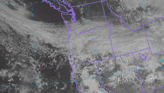
Yesterday was a good example of the problem. A frontal band oriented east-west moved northward over Oregon. Here is the visible satellite picture at 11:30 AM Thursday.
The 12-h precipitation totals ending about the same time showed precipitation on both sides of the Oregon Cascades (I suspect the larger east side amount of several inches are in error). In any case, several locations got .5-1 inch on the eastern side of the Oregon Cascades.

Map covering the northern Oregon Cascades. The Willamette Valley is on the left side.
The Portland radar "storm total" product shows plenty on the western slopes, but way less east of the Cascades...clearly less than observed on the ground.

The problem is even larger looking westward using the Pendleton radar.

I could give you a dozen other examples of poor eastern-slope weather radar coverage. The solution is probably to secure 2 or 3 modest "C" band radars, each with a range of a few hundred km. This will take substantial resources (perhaps as much as a million dollars ) and funds for maintenance and installation. But I suspect the cost-benefit analysis for the region would be very favorable and the expenses could be shared by local, state, and Federal entities. I wish the new group luck in their endeavor.

.gif)


Love too see a radar along the central oregon coast which would really Improve in seeing incoming storms from the SW, but it sounds like it could be years or decades before anything will be done what a shame, keep up the good work cliff.
ReplyDeleteSee if you can get in contact with the cherry growers. Cherries are a crop that is very sensitive to rain near harvest (they have helicopters on standby for several weeks to help dry the crop if there's rain) and grown in an areas of Washington with very poor radar coverage.
ReplyDeleteAs a meteorologist working for a state agency in Oregon, central Oregon coverage gaps are a big challenge to work around, and surface observations/WIMS stations are isolated. Any movement on this would be welcome!
ReplyDeleteI wonder if NWS Pendleton would support it if their Spokane colleagues have already started rolling the ball?
$1m isn't very much in government terms; Seattle's budget was about $4.5b this year. I don't understand why something like this should be a struggle given all the benefits you listed.
ReplyDeleteI've been saying for about a decade now that there should be a Doppler radar installation on Glass Butte on Central Oregon. It’s only ~2,000 HAAT, there’s power running right up to the summit, and there’s a large commercial transmitter site. OPB has their translator K26KQ-D-26 up there, too. It would be the absolute PERFECT spot!
ReplyDeletePine Mountain just SE of Bend has been mentioned as a good spot, but there’s an observatory up there. They may not want a large, high-powered 10GHz transmitter sitting there making noise right next to their receiving equipment. Glass Butte is about 50 miles farther to the ESE.
I agree with the need for the two proposed sites in Oregon and would propose a WSR-88 on 3,500' Rattlesnake Peak for coverage of the Cascade East Slopes and the ag areas of the Yakima and Wenatchee Valleys as well as the Columbia Basin. This should also provide Doppler velocity data for this area.
ReplyDeleteIncidentally, that 10 fold increase in computer power of the European models over the U.S. guidance was apparent in Eastern Washington where the U.S. product predicted 4-8" of snow never materialized this week. The Euros looked to be much closer to the mark.
$1m for a bunch of them? That's nearly Kickstarter territory, and it's certainly within the margin of Congressional rounding errors! Depressing that this hasn't happened already... how many millions have they spent freaking out over Ebola, or replacing the naked scanners at airports? Never mind cutting back on just a couple of bombs or drones. UGH.
ReplyDeleteCliff, do you have a more recent post regarding the NWS Radar Gap? I would love to see if technology's evolution has improved the coverage of the area.
ReplyDelete