There was some nice sun in Seattle this afternoon and that was ironically a good sign for mountain snow lovers. How could that be true?
First, the sun...here are a few cam shots Saturday afternoon..one looking at Seattle from Queen Anne and the other from the UW.
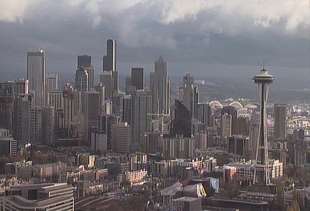

There were even blue skies, particularly over the Sound and the Kitsap Peninsula...a visible satellite image around the same time confirms this:

But at the same time, it was completely cloudy over the Cascades and the Olympics, with snow falling from roughly 3500 ft and above. As proof, here are some cam shots at Crystal Mountain and Stevens.


Is there a connection between Seattle sun and Stevens/Crystal snow?
You bet there is.
After the front went through Friday night the winds aloft turned from southerly and southwesterly to westerly and northwesterly. I can show this change from the winds above Seattle-Tacoma Airport shown in the following image. The winds are shown by the pennants and temperatures are in red. The vertical axis is pressure (850 hPa is about 5000 ft, 700 hPa about 10,000 ft. The x-axis is time in UTC (22/06 is 10 PM Friday night). The front was associated with a wind shift and the rapid decline in temperatures aloft.

The Cascades are oriented roughly north-south and thus westerly winds (from the west) are forced to rise on the mountains sharply since the winds are directly right up the height gradient. That rising motion produces cooling and saturation, resulting in clouds and precipitation, and in this case snow! Southerly winds do not ascend the mountain much.
When air goes DOWN \terrain it warms, dries and clouds dissipate. For westerly or northwesterly flow, like we had this afternoon, the air rises on the Olympics (producing clouds and precipitation on the western side of those mountains), but sinks on the eastern side of the Olympics, producing clearing skies west of and over the Sound. The westerly flow then rises again on the Olympics giving snow.
You seen this happening in a recent weather radar image. Dry over Puget Sound, but lots of precipitation on the western slopes and crest of the Cascades.

So Seattle's clearing is a good indication of strong westerly flow and thus good potential for snow in the Cascades if the air is cold enough.
I know...you want to know how much snow will fall before Thanksgiving. Here is the predicted total snow for the 72 h starting 4 AM today (Saturday). 1-2 feet in some locations of the central and northern Cascades. I am pretty sure there won't be enough for Snoqualmie, but perhaps for Stevens, Baker, and Crystal. But it will be close. But there is a problem....warm air is coming.

And if any of you would like to read about on snow in mountains, there is a very good book on mountain snow that has just come out:
Secrets of the Greatest Snow on Earth: Weather, Climate Change, and Finding Deep Powder in Utah's Wasatch Mountains and around the World
.jpg)
This is written by a colleague of mine (and a graduate of my department) Professor Jim Steenburgh of University of Utah. This book not only explains why Utah's mountains enjoy such good snow, but describes the mechanisms of mountain snow, avalanches, and many other general snow topics. And there are lots of marvelous pictures. Jim is an expert in mountain meteorology, is crazy about mountain snow, and has spent an extraordinary amount of time skiing.
Ordering information:
Barnes and Noble (paperback and nook): http://www.barnesandnoble.com/w/secrets-of-the-greatest-snow-on-earth-jim-steenburgh/1119400829?ean=9780874219500
Utah State University Press (paperback and e-book): http://www.usupress.com/book/_welcome_usup/9500
Amazon.com
http://www.amazon.com/Secrets-Greatest-Snow-Earth-Mountains/dp/0874219507/
Of course, there is another book that touches on these subjects, but at lesser depth.


Does Whistler benefit from this? What about the Powder Highway resorts?
ReplyDeleteIt looks like a different system but I don't know how to read those maps accurately.
If someone has a detailed primer on interpreting this data I'd love to read it :)
The petition for the weather-prediction supercomputer stands at 654 signatures. It would be awesome to crack 1000... it's really slowed down since it fell off the front page of the We the People site.
ReplyDeleteSign here
Thanks!
The GFS this morning is the coldest run yet- definitely something to watch for this weekend. Right now it is advertising dry and cold, with no system to provide precipitation. Hoping that will change! We deserve some snow around here at some point...
ReplyDelete